Senegal Country Facts

Official Name: Republic of Senegal
Alternate Names: Senegal
 Former Names: Senegambia (included The Gambia), Mali Federation
Capital City: Dakar
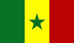
Flag: The Senegalese flag has three equal vertical bands of green, yellow, and red with a small five-pointed green star in the middle of the yellow band.
Date of Independence: April 4, 1960 from France with complete separation from the Mali Federation on August 20, 1960.
National Anthem: "Pincez Tous vos Koras, Frappez les Balafons" (Pluck Your Koras, Strike the Balafons)
Population: 12,534,000
 Size/Area: 196,723 sq km, slightly smaller than South Dakota
Land Locked: No
Coastline: 531 km
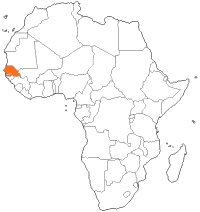
Bordering Countries: The Gambia, Guinea, Guinea-Bissau, Mali, Mauritania
Administrative Divisions: Senegal is divided into 14 regions - Dakar, Diourbel, Fatick, Kaffrine, Kaolack, Kédougou, Kolda, Louga, Matam, Saint-Louis, Sédhiou, Tambacounda, Thiès, Ziguinchor.
Major Cities: Dakar, Touba, Thiès, Kaolack, M'Bour, Saint-Louis, Rufisque, Ziguinchor
Languages: French (Official), Wolof, Soninke, Seereer-Siin, Fula, Maninka, Diola.
Religions: Islam, Christian, animism
Major Holidays: New Year's Day, Tamkharit (Ashoura), Independence Day (Apr 4), Easter Monday, Labour Day (May 1), Ascension, Whit Monday, Assumption, Korité (End of Ramadan) (Sept 21), All Saints' Day (Nov 1), Tabaski (Feast of the Sacrifice), Tamkarit (Islamic New Year), Christmas Day.
Currency: CFA Franc
Currency Code: XOF
Highest Point: An unnamed place near Nepen Diakha at 581 m
Lowest Point: Atlantic Ocean
Bordering Bodies of Water: Atlantic Ocean
Climate: Tropical. Hot and humid with a rainy rainy season from May to November. The dry season from December to April is dominated by a hot, dry, wind.
Major Industries: Food processing, mining, cement, artificial fertilizer, chemicals, textiles, refining imported petroleum, and tourism.
Major Agricultural Products: Peanuts, millet, corn, sorghum, rice, cotton, tomatoes, green vegetables, cattle, poultry, pigs, fish
Natural Resources: Fish, phosphates, and iron ore
Time Zone: UTC
Interesting Facts: The capital city of Dakar is the western most point of Africa.
 Tribes of Africa eBook
This eBook is the most complete listing of African tribes available on the internet. The first section of this book is the tribes sorted alphabetically by country. The second section is the tribes sorted alphabetically by tribe name.
Alternate Names: Senegal
Former Names: Senegambia (included The Gambia), Mali FederationCapital City: Dakar
Flag: The Senegalese flag has three equal vertical bands of green, yellow, and red with a small five-pointed green star in the middle of the yellow band.
Date of Independence: April 4, 1960 from France with complete separation from the Mali Federation on August 20, 1960.
National Anthem: "Pincez Tous vos Koras, Frappez les Balafons" (Pluck Your Koras, Strike the Balafons)
Population: 12,534,000
Size/Area: 196,723 sq km, slightly smaller than South DakotaLand Locked: No
Coastline: 531 km
Bordering Countries: The Gambia, Guinea, Guinea-Bissau, Mali, Mauritania
Administrative Divisions: Senegal is divided into 14 regions - Dakar, Diourbel, Fatick, Kaffrine, Kaolack, Kédougou, Kolda, Louga, Matam, Saint-Louis, Sédhiou, Tambacounda, Thiès, Ziguinchor.
Major Cities: Dakar, Touba, Thiès, Kaolack, M'Bour, Saint-Louis, Rufisque, Ziguinchor
Languages: French (Official), Wolof, Soninke, Seereer-Siin, Fula, Maninka, Diola.
Religions: Islam, Christian, animism
Major Holidays: New Year's Day, Tamkharit (Ashoura), Independence Day (Apr 4), Easter Monday, Labour Day (May 1), Ascension, Whit Monday, Assumption, Korité (End of Ramadan) (Sept 21), All Saints' Day (Nov 1), Tabaski (Feast of the Sacrifice), Tamkarit (Islamic New Year), Christmas Day.
Currency: CFA Franc
Currency Code: XOF
Highest Point: An unnamed place near Nepen Diakha at 581 m
Lowest Point: Atlantic Ocean
Bordering Bodies of Water: Atlantic Ocean
Climate: Tropical. Hot and humid with a rainy rainy season from May to November. The dry season from December to April is dominated by a hot, dry, wind.
Major Industries: Food processing, mining, cement, artificial fertilizer, chemicals, textiles, refining imported petroleum, and tourism.
Major Agricultural Products: Peanuts, millet, corn, sorghum, rice, cotton, tomatoes, green vegetables, cattle, poultry, pigs, fish
Natural Resources: Fish, phosphates, and iron ore
Time Zone: UTC
Interesting Facts: The capital city of Dakar is the western most point of Africa.
Tribes of Africa eBookThis eBook is the most complete listing of African tribes available on the internet. The first section of this book is the tribes sorted alphabetically by country. The second section is the tribes sorted alphabetically by tribe name.
This site needs an editor - click to learn more!
You Should Also Read:
Gambia Country Facts
Mali Country Facts
Liberia Country Facts
Related Articles
Editor's Picks Articles
Top Ten Articles
Previous Features
Site Map
Content copyright © 2023 by Jeanne Egbosiuba Ukwendu. All rights reserved.
This content was written by Jeanne Egbosiuba Ukwendu. If you wish to use this content in any manner, you need written permission. Contact
BellaOnline Administration
for details.