Chantry Flats
Looking for a place to spend a mental health day, but trying to avoid wasting gas? Those who live in the Los Angeles basin are in luck – directly above the Santa Anita race track in Arcadia, an entirely different world awaits. While insanely crowded (and thus best avoided) on weekends, the Chantry Flats area is almost completely deserted during the week, making it a fantastic place to go for solitude, natural beauty, and exercise.
Chantry Flats is right off the 210 freeway at the Santa Anita exit. Driving north, one crosses two stoplights and a few last blocks of houses before leaving the city behind. The road winds and switchbacks up the mountain into Big Santa Anita Canyon, finally ending at a parking lot, pack station, and picnic area. For some, this enough; it’s easy to spend an entire afternoon seated under the trees, writing, reading, practicing yoga, or simply relaxing. For others, however, this is just the beginning of a day spent hiking under the shadows of oaks and in the presence of chaparral.
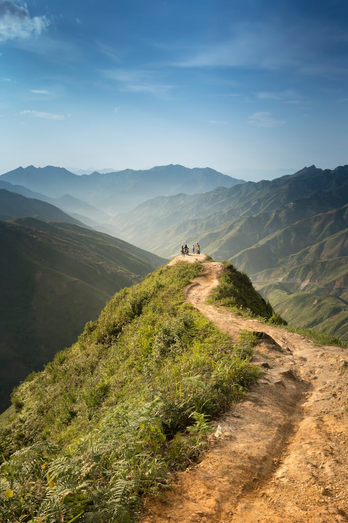
The fire road at the parking lot leads down into the canyon for three-quarters of a mile. Once in the canyon, four main trails can be reached. The most popular trail is the hike to Sturtevant Falls, which is fairly flat, wide, and scenic. The path winds around private cabins and flood control dams before ending in a wide clearing that turns into a waterfall during a wet winter. Even without the water, the end of the trail is beautiful, with boulders offering seating to view the rocky cliffs and natural beauty that surrounds the area. From here, one can either return the way one came or take one of the trails that intersects; it’s possible, for example, to combine this hike with a trail leading to Hermit Falls and then return to the parking area via the First Water Trail, which intersects the fire road halfway up the canyon wall.
Another popular hike in this area is also reached via the fire road. Instead of following the signs to Sturtevant or Hermit Falls, one can take the Lower Winter Creek Trail to the Upper Winter Creek Trail and explore the top part of the canyon – a total of around five miles. These are more difficult trails, but the lush elevation and the ability to view the entire canyon area from above more than makes up for the additional effort.
Backpackers often use this area as a staging ground for multi-day trips into the Angeles National Forest. Both the Sturtevant Falls and Winter Creek Trails connect with the Gabrielino Trail, which winds northwest towards Altadena and to trails connecting to picnic areas off of the Angeles Crest Highway, as well as to trails leading directly north (and up!) to Mount Wilson. It is possible to spend as much time hiking and camping in this area as one wishes, and the trails can be accessed from a variety of other points that connect to Chantry Flats via the trail system.
An Adventure Pass can be purchased at the REI store three blocks south of the freeway exit at Santa Anita. Remember to bring water – this area is dusty, and the non-shaded parts get hot at any time of the year. Photographers will be reaching for their cameras, as there is much natural beauty to photograph. The best part? At the end of one’s afternoon or day “retreat”, one has a very short drive to reach home. Chantry Flats, like other areas in the foothills of the San Gabriel Mountains, is part of the best that Los Angeles has to offer for the hiking and camping crowd. Enjoy the area responsibly, and return to work refreshed and renewed.
Chantry Flats is right off the 210 freeway at the Santa Anita exit. Driving north, one crosses two stoplights and a few last blocks of houses before leaving the city behind. The road winds and switchbacks up the mountain into Big Santa Anita Canyon, finally ending at a parking lot, pack station, and picnic area. For some, this enough; it’s easy to spend an entire afternoon seated under the trees, writing, reading, practicing yoga, or simply relaxing. For others, however, this is just the beginning of a day spent hiking under the shadows of oaks and in the presence of chaparral.
The fire road at the parking lot leads down into the canyon for three-quarters of a mile. Once in the canyon, four main trails can be reached. The most popular trail is the hike to Sturtevant Falls, which is fairly flat, wide, and scenic. The path winds around private cabins and flood control dams before ending in a wide clearing that turns into a waterfall during a wet winter. Even without the water, the end of the trail is beautiful, with boulders offering seating to view the rocky cliffs and natural beauty that surrounds the area. From here, one can either return the way one came or take one of the trails that intersects; it’s possible, for example, to combine this hike with a trail leading to Hermit Falls and then return to the parking area via the First Water Trail, which intersects the fire road halfway up the canyon wall.
Another popular hike in this area is also reached via the fire road. Instead of following the signs to Sturtevant or Hermit Falls, one can take the Lower Winter Creek Trail to the Upper Winter Creek Trail and explore the top part of the canyon – a total of around five miles. These are more difficult trails, but the lush elevation and the ability to view the entire canyon area from above more than makes up for the additional effort.
Backpackers often use this area as a staging ground for multi-day trips into the Angeles National Forest. Both the Sturtevant Falls and Winter Creek Trails connect with the Gabrielino Trail, which winds northwest towards Altadena and to trails connecting to picnic areas off of the Angeles Crest Highway, as well as to trails leading directly north (and up!) to Mount Wilson. It is possible to spend as much time hiking and camping in this area as one wishes, and the trails can be accessed from a variety of other points that connect to Chantry Flats via the trail system.
An Adventure Pass can be purchased at the REI store three blocks south of the freeway exit at Santa Anita. Remember to bring water – this area is dusty, and the non-shaded parts get hot at any time of the year. Photographers will be reaching for their cameras, as there is much natural beauty to photograph. The best part? At the end of one’s afternoon or day “retreat”, one has a very short drive to reach home. Chantry Flats, like other areas in the foothills of the San Gabriel Mountains, is part of the best that Los Angeles has to offer for the hiking and camping crowd. Enjoy the area responsibly, and return to work refreshed and renewed.
You Should Also Read:
Angeles Crest Highway
Hahamonga Regional Park

Related Articles
Editor's Picks Articles
Top Ten Articles
Previous Features
Site Map
Content copyright © 2023 by Korie Beth Brown, Ph.D. . All rights reserved.
This content was written by Korie Beth Brown, Ph.D. . If you wish to use this content in any manner, you need written permission. Contact Korie Beth Brown, Ph.D. for details.