Lesotho Country Facts

Official Name: Kingdom of Lesotho
Alternate Names: Lesotho
Former Names: Basutoland
Capital City: Maseru
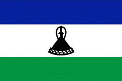 Flag: The flag has three horizontal stripes of blue (on the top), white, and green. The color blue represents rain. The color white represents peace. The color green represents prosperity. In the center of the white stripe is a black Basotho hat which represents the indigenous people of Lesotho.
Date of Independence: October 4, 1966 from the United Kingdom
National Anthem: "Lesotho fatse la bo ntat'a rona" (Lesotho, Land of Our Fathers)
Population: 1,924,886
Size/Area: 18861 square miles - slightly smaller than Maryland
Land Locked: Yes
Coastline: None
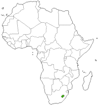 Bordering Countries: Lesotho is completely surrounded by South Africa
Administrative Divisions: Lesotho is divided into ten districts: Berea, Butha-Buthe, Leribe, Mafeteng, Maseru, Mohale's Hoek, Mokhotlong, Qacha's Nek, Quthing, Thaba-Tseka.
Major Cities: Maseru
Languages: Sesotho (official), English (official), Zulu, Xhosa
Religions: Christian 80%, indigenous beliefs 20%
Major Holidays: New Year's Day, Moshoeshoe Day (March 11), Good Friday, Easter Monday, Workers' Day (May 1), Ascension, Africa Day / Heroes' Day (May 25), King Letsie III's Birthday (July 17), Independence Day (October 4), Christmas Day, Boxing Day
Currency: Lesotho Loti
Currency Code: LSL
Highest Point: Thabana Ntlenyana at 11,423 feet
Lowest Point: Lesotho's lowest point is at the junction of the Orange and Makhaleng Rivers and is 4593 feet above sea level.
Bordering Bodies of Water: None
Climate: temperate; cool to cold, dry winters; hot, wet summers
Major Industries: Food, beverages, textiles, apparel assembly, handicrafts, construction, tourism
Major Agricultural Products: Corn, wheat, pulses, sorghum, barley; livestock
Natural Resources: Water, agricultural and grazing land, diamonds, sand, clay, building stone
Time Zone: UTC+2
 Tribes of Africa eBook
This eBook is the most complete listing of African tribes available on the internet. The first section of this book is the tribes sorted alphabetically by country. The second section is the tribes sorted alphabetically by tribe name.
Alternate Names: Lesotho
Former Names: Basutoland
Capital City: Maseru
Flag: The flag has three horizontal stripes of blue (on the top), white, and green. The color blue represents rain. The color white represents peace. The color green represents prosperity. In the center of the white stripe is a black Basotho hat which represents the indigenous people of Lesotho.Date of Independence: October 4, 1966 from the United Kingdom
National Anthem: "Lesotho fatse la bo ntat'a rona" (Lesotho, Land of Our Fathers)
Population: 1,924,886
Size/Area: 18861 square miles - slightly smaller than Maryland
Land Locked: Yes
Coastline: None
Bordering Countries: Lesotho is completely surrounded by South AfricaAdministrative Divisions: Lesotho is divided into ten districts: Berea, Butha-Buthe, Leribe, Mafeteng, Maseru, Mohale's Hoek, Mokhotlong, Qacha's Nek, Quthing, Thaba-Tseka.
Major Cities: Maseru
Languages: Sesotho (official), English (official), Zulu, Xhosa
Religions: Christian 80%, indigenous beliefs 20%
Major Holidays: New Year's Day, Moshoeshoe Day (March 11), Good Friday, Easter Monday, Workers' Day (May 1), Ascension, Africa Day / Heroes' Day (May 25), King Letsie III's Birthday (July 17), Independence Day (October 4), Christmas Day, Boxing Day
Currency: Lesotho Loti
Currency Code: LSL
Highest Point: Thabana Ntlenyana at 11,423 feet
Lowest Point: Lesotho's lowest point is at the junction of the Orange and Makhaleng Rivers and is 4593 feet above sea level.
Bordering Bodies of Water: None
Climate: temperate; cool to cold, dry winters; hot, wet summers
Major Industries: Food, beverages, textiles, apparel assembly, handicrafts, construction, tourism
Major Agricultural Products: Corn, wheat, pulses, sorghum, barley; livestock
Natural Resources: Water, agricultural and grazing land, diamonds, sand, clay, building stone
Time Zone: UTC+2
Tribes of Africa eBookThis eBook is the most complete listing of African tribes available on the internet. The first section of this book is the tribes sorted alphabetically by country. The second section is the tribes sorted alphabetically by tribe name.
This site needs an editor - click to learn more!
You Should Also Read:
Flags of Africa - Countries Starting With L
Southern Africa 
Related Articles
Editor's Picks Articles
Top Ten Articles
Previous Features
Site Map
Content copyright © 2023 by Jeanne Egbosiuba Ukwendu. All rights reserved.
This content was written by Jeanne Egbosiuba Ukwendu. If you wish to use this content in any manner, you need written permission. Contact
BellaOnline Administration
for details.